The Conservation Assessment and Prioritization System (CAPS) is a computer model and sophisticated approach to assessing the ecological integrity of ecosystems. It is being used as a level 1 assessment methodology as part of a comprehensive wetlands assessment and monitoring program for Massachusetts. When credible models of ecological integrity can be developed we use them to get a comprehensive assessment of all Massachusetts wetlands and use it to guide field-based assessments (rapid or intensive) and policy/management to maintain or improve wetland condition.
For the past several years we have been using data collected in the field to compare the Indices of Ecological Integrity (IEI) calculated by CAPS with biological field data collected in streams, forested wetlands, salt marshes, and, more recently, shrub swamps. From these field data we have been able to calculate robust Indices of Biological Integrity (IBIs) that correspond to IEI gradients for streams and forested wetland, but not salt marshes. Salt marshes are probably the most threatened wetland type in Massachusetts and are particularly vulnerable to the effects of sea level rise.
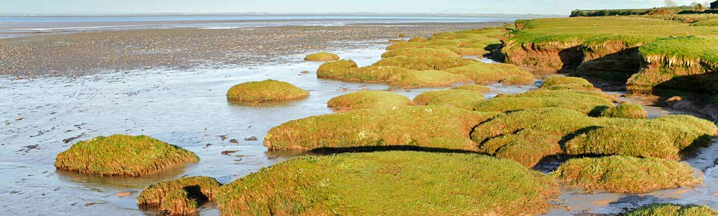
We have several possible explanations for why we have not yet been able to correlate CAPS IEI scores with field indices of salt marsh condition. Any, all, or various combinations of factors may be affecting our ability to model ecological integrity or assess condition in the field for salt marshes. However, we believe that the main reason may be that the CAPS IEI model for salt marshes lacks metrics for important salt marsh stressors related to sediment dynamics, effects of increased nutrient loading on peat accretion, changes in marsh elevation relative to sea level rise, crab herbivory, and crab burrowing effects on peat density and stability. We have engaged in a project to investigate alternative ways of assessing salt marsh condition and vulnerability focusing on physical indicators of marsh condition and plant stress/productivity.
Field work in salt marshes is difficult because tide cycles affect our ability to access interior portions of marshes and to see/evaluate marsh characteristics due to ever changing water levels. Remote sensing (satellite imagery; aerial photographs) offer some potential for assessing salt marsh characteristics. However, these data may not be available at stages in the tide cycle when specific characteristics need to be assessed, such as high tide for assessing high marsh flooding or low tide for assessing creek bank stability.
We propose to investigate the use of unmanned aerial systems (UAS) to collect data when timing is critical and test the potential of using various sensors to assess vegetation health/stress and physical characteristics of salt marshes. These data will be calibrated and assessments validated using data collected on the ground, and will be used to calibrate and test other remotely sensed data (satellite and aerial photographs). The goal is to use UAS technology as part of a nested approach to remote sensing (also including satellite data and aerial photographs) to assess the physical and perhaps biological (e.g. plant stress) condition of salt marshes.
Once a system has been developed for assessing salt marsh condition using remote sensing, perhaps supplemented by limited ground data collection, it will be used to assess a large number of sites across the full range of salt marshes in Massachusetts. From these data we will use landscape-scale modeling to create CAPS metrics for characterizing stressors affecting salt marshes and create an IEI model for salt marshes that reflects biological and physical condition as evaluated in the field.
It is expected to take 4-8 years to complete this work. In this first phase of the work we are focusing on the exploration, refinement and calibration of remote sensing using UAS in order to assess salt marsh condition with respect to physical degradation, flooding and plant stress.Implement via ground-based surveys, a classification system for salt marsh vegetation, water features and patches of bare ground, and document areas of marsh stress and degradation (e.g. creek widening, bank instability, crab herbivory, areas of high crab burrow density, marsh subsidence, and unexplained salt marsh dieback)
- Use data collected during ground-based surveys to train computer models to automate the mapping of salt marsh vegetation, bare ground and water features using remotely sensed data.
- Use Technology (e.g. RGB, NIR, Rededge & SWIR) to assess physical characteristics of salt marshes with the objective of identifying areas of degradation using remotely sensed data. These UAS assessments will be compared to assessment conducting using ground-based field surveys.
- Use UAS technology to document the extent of high marsh flooding at low tide, neap high tide, and spring high tide to identify permanent water features, inappropriate high marsh flooding (i.e. drowning), and effects of tidal restrictions
- Use UAS technology to investigate the potential to use remote sensing to identify areas of plant stress focusing on areas of salt marshes experiencing stress as indicated by physical degradation and inappropriate flooding.
- Evaluate three CAPS metrics (tidal restrictions, salt marsh ditching and connectedness) for relationships with the three indicators of marsh condition: physical integrity, flooding, and plant stress.
Our Field Survey Approach:
June/July 2019
A two-person field crew will install 7-10 ground control points (GCPs) in a systematic way throughout the marsh. Ground control points are 1ft x 1ft square platforms that are connected to a stake and inserting into the marsh peat (see picture below). We will also install 6-9 sediment traps on the marsh surface throughout the marsh. A sediment trap is a shallow “bucket” that is 1ft. in diameter and 2 inches deep.

Installing and locating a GCP.
Mapping the location of a creek edge.
June – October 2019
After ground control points are installed, we use a drone with special sensors to survey the salt marsh study area. Ground control points are necessary to ensure the accuracy of drone imagery. The drone is quiet, flies at 400 feet, and does not fly over houses, occupied vehicles, or people. Except for take-offs and landings, drone flights will occur only over the salt marsh. We are currently working with the USFWS and MA Division of Fisheries and Wildlife to develop procedures for operating the drone in areas near where piping plovers and terns may be nesting. Expect to collect UAS imagery once a month throughout the growing season.
August – October 2019
Finally, when salt marsh vegetation is well developed late in the season (August and September), two-person field crew will walk over the marsh surface and use a GPS device to map vegetation types, areas of bare ground and water features on the marsh. This process takes 2-4 days to cover the entire study site and occurs at low tide.